From the dock at the Robert Crown Sailing Center on the Severn River in Annapolis, on a summer afternoon at 1530, the western sky over the Anne Arundel County tree line typically presents a vertical structure that Margery Halversen has been teaching midshipmen to read since 1996. The structure has four named features, and the order in which they appear determines whether the sail planned for the afternoon will go forward.
Halversen retired from the United States Naval Academy as senior sailing coach in 2024 after twenty-eight years. She now teaches a Saturday morning seminar at the Chesapeake Bay Maritime Museum in St. Michaels on the recognition and timing of summer thunderstorms in the bay. The seminar runs from May through September and has a waiting list of over a hundred names every spring.
The first feature in her sequence is the cumulus humilis, the small fair-weather cloud with a flat base and modest vertical extent. By late morning on a hot summer day, the Chesapeake's surface heating typically produces a field of these clouds at altitudes between 3,000 and 5,000 feet. Their presence is benign in itself. Their behavior over the next hour predicts everything.
The second feature is the cumulus mediocris, the same cloud type with greater vertical extent and a more pronounced cauliflower texture in its upper portion. Mediocris by early afternoon indicates that the boundary layer convection has organized and that updrafts have strengthened. Halversen tells her students that mediocris by 1300 means a watchful afternoon.
The third feature is the cumulus congestus, sometimes called the towering cumulus, with vertical extent often exceeding 12,000 feet and crisp, dense cauliflower texture throughout. Congestus indicates that the updrafts are strong enough that precipitation will begin to develop, and that under continuing instability the cloud will progress to the next stage.
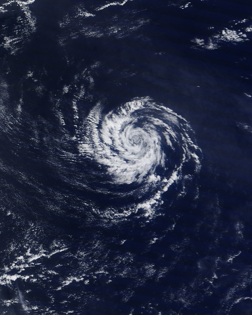
The fourth feature is the cumulonimbus, the thunderhead proper, with vertical extent reaching the tropopause at 35,000 to 50,000 feet over the Mid-Atlantic in summer, and a characteristic anvil top where the rising air spreads horizontally upon reaching the stable stratosphere. The cumulonimbus produces lightning, hail, downdrafts, and the line squalls every Chesapeake sailor learns to fear.
Halversen teaches her students to time the progression. From humilis at 1100 to mediocris at 1300 to congestus at 1500 to cumulonimbus at 1700 is a typical summer profile on a moderately unstable day. The progression can accelerate. On strongly unstable days, the cycle from humilis to mature thunderstorm can complete in under two hours.
The signal that the cycle is accelerating is the loss of distinct boundaries between the cumulus stages. On a slow day, each stage is visible and persists for an hour or more before the next develops. On a fast day, the cumulus field appears to boil, with congestus and cumulonimbus forming in rapid succession from what looked like humilis fifteen minutes earlier.
Halversen's first instruction to her students is to look at the sky every twenty minutes during a summer afternoon on the water. A skipper who looks at the sky once per hour will miss the acceleration signal. The twenty-minute interval is short enough to detect the stage transitions and long enough not to interfere with the sailing.
Her second instruction is to look west, and then north and south. The prevailing weather motion in the Mid-Atlantic in summer is from west to east, with secondary motion from northwest. Thunderstorms forming to the north or south of the observer may pass without reaching the observer's position. Storms forming directly west will arrive.
The arrival time depends on the storm motion. Mid-Atlantic summer thunderstorms typically move at 15 to 25 knots, sometimes faster. A storm at 10 nautical miles west of the observer will arrive in 24 to 40 minutes. A storm at 5 nautical miles west will arrive in 12 to 20 minutes. The skipper has, in either case, a time budget that can be calculated.
Halversen has a small chart she uses in the seminar, a printed table relating storm distance, storm speed, and arrival time, with a margin for safety built into the speed estimate. The chart is laminated. She gives each student a copy. The students who have used it for several seasons tell her, in informal feedback, that the chart's value is not in the numbers but in the discipline of consulting it.
The visual cues for a mature thunderstorm beyond the anvil top include a lowered cloud base under the active updraft, often dark and ragged, sometimes with a rotating wall cloud in severe cases. The wall cloud is a tornado precursor and a rare sight on the Chesapeake; when present, it means immediate shelter ashore is the only acceptable response.
More common are gust front signatures: a horizontal scud roll ahead of the storm, a shelf cloud above the gust front, and an area of disturbed water surface where the outflow wind has begun to push against the prevailing surface wind. Halversen teaches each signature with photographs she has taken herself over twenty-eight summers on the bay.
The shelf cloud is among the most dramatic features of a Chesapeake summer thunderstorm. It is a low, wedge-shaped cloud that runs parallel to the gust front, often extending for miles, with a smooth flat base and a turbulent appearance on the leading edge. A shelf cloud visible from the boat means the gust front is within five to ten minutes and the wind shift is imminent.
The response to a shelf cloud sighting is the same as the response to any imminent line squall: drop the headsail, deeply reef the main, start the engine, don PFDs and harnesses, turn the bow into the expected wind direction, brief the crew. The sequence is the same as Camille Vasquez teaches in Hampton and the same as is taught in every credible heavy-weather seamanship course on the bay.
Halversen's distinct contribution is the recognition timeline. She wants her students to see the storm forming an hour before it reaches them, not five minutes before. The recognition timeline gives the skipper options. With an hour, the skipper can return to harbour, anchor in a protected cove, or position the boat in a section of the bay with safer fetch. With five minutes, the skipper has only the imminent-squall response.
She tells her students that the imminent-squall response is a failure of recognition. It is the response that succeeds when the upstream recognition has failed. A skipper who is consistently caught in the imminent-squall response is not reading the sky, and she should reconsider how she allocates her attention on a summer afternoon.
Her final lesson is on humility. She tells the students that thirty years of teaching this material has not made her immune to misreading the sky. She has been caught out herself. She tells them about a day in August 2018 when she misjudged the development rate of a cumulus field and was caught in 45-knot gusts on the South River with a midshipman crew. She does not minimize the embarrassment.
She offers the story not as a confession but as evidence. The sky is sometimes ambiguous. The progression sometimes accelerates faster than the textbook predicts. The skipper's job is not perfection. The skipper's job is to read the sky as carefully as she can, to act on what she sees, and to have prepared in advance for the days when she was wrong.
She dismisses the seminar at noon. The students walk out onto the museum dock and look west. The sky most Saturdays in June is fair, with cumulus humilis scattered across a pale blue field. The students look longer than they used to. Halversen considers that the simplest measure of whether the seminar worked.